↓
 

Nashville Civil Engineering

...a Pro17 Engineering marketing website.

Nashville Civil Engineering
(615) 933-1003
Nashville Civil Engineering
  • Home
  • Civil Engineering
  • Construction Management
  • Drone LiDAR Mapping
  • Environmental Engineering
  • Expert Witness
  • Land Development Services
  • Land Surveying Services
  • Structural Engineering
  • Transportation Engineering
Home 1 2 >>

Post navigation

← Older posts

Subdivision Engineering Is Becoming More Complex

Civil engineers reviewing subdivision engineering plans and 3D models for roads, utilities, and stormwater drainage design.

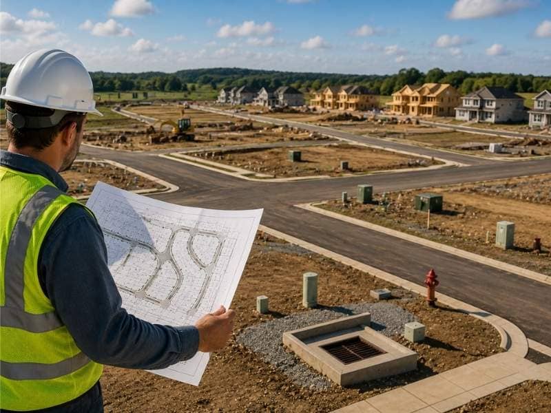
Subdivision engineering used to follow a fairly steady set of steps. Lay out the lots, design the roads, route the water and sewer, then submit the plans. That work is getting harder. New rules, tougher drainage standards and tighter utility layouts now ask far more of every plan. The result is a process with more moving parts and less room for error. Engineers who plan for that complexity early keep their projects on track. The ones who don’t tend to lose time in review.

Why Subdivision Engineering Has More Rules to Follow

The rulebook for new subdivisions keeps growing. A plan that once cleared one local office now passes through several. Stormwater permits, environmental reviews, fire access and road rules each bring their own checklist.

Many of these rules tie back to safety and the environment. A town wants streets wide enough for fire trucks. A state wants runoff that won’t pollute a nearby creek. Each goal adds a standard the design has to meet.

These layers also stack on top of each other. A change to meet one rule can break another. Move a road for better drainage, and you might shrink a lot below the minimum size. Engineers now spend more time making sure every rule fits together before a plan goes in for review.

How Drainage Planning Plays a Bigger Role in Subdivision Engineering

Drainage used to be a late step. Now it shapes the whole layout. Rules often make a subdivision hold back its own rainwater and let it out slowly, so nearby land doesn’t flood.

That single rule changes a lot. The design has to find space for ponds or basins. That space can take up land that would have held more lots. Road grades, lot pads and yard slopes all have to send water where the plan wants it.

Newer standards go a step further and ask for cleaner runoff, not just less of it. The design may need features that filter out dirt and oil before water leaves the site. Strong drainage planning protects the roads, the homes and the land downstream all at once. Weak planning shows up later as standing water, washed-out streets and frustrated neighbors.

Why Utility Design Takes More Planning Today

A subdivision packs a lot of pipes and lines into a tight space. Water, sewer, storm drains, power, gas and internet all share the same ground. Each one needs room. It also has rules about how close it can sit to the others.

That is why utility design takes more planning today. Sewer lines usually run by gravity, so they set the depth other lines must work around. Water lines have to stay a safe distance from sewer to keep the supply clean. Fit these together wrong on paper, and crews hit conflicts in the field.

A field conflict gets expensive fast. It can stop digging, force a redesign and push back every task that follows. Careful layout up front maps every line in 3D. That helps a crew build the system once instead of twice.

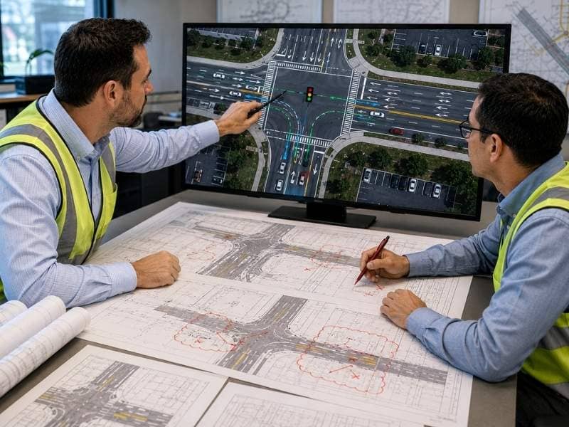
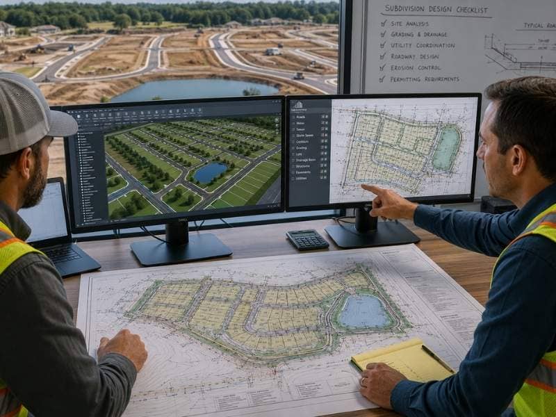
How New Technology Helps With Subdivision Engineering

Modern design software has changed how subdivisions come together. Engineers now build the whole site as a 3D model instead of flat lines on paper. The model shows how roads, lots and pipes relate before anyone breaks ground.

This helps in two big ways. First, the software can scan the design for clashes. It can catch a water line crossing a storm drain early. Second, it can figure out how much dirt to cut or fill, which keeps grading costs in check.

The bigger payoff is handling change. A reviewer asks for a wider road, and the model updates the affected grades, lots and drainage in minutes. Older methods meant redrawing sheets by hand for days. Faster updates mean fewer mistakes and a quicker path through review.

Why Early Planning Can Prevent Problems Later

The smartest move here happens before the first lot line. Engineers study the site’s soil, slope and features, then let those facts guide the layout. A plan built around the land tends to hold up. A plan forced onto the land tends to break.

Early study answers questions that get costly later. Soft soil might rule out a road in one spot. A steep slope might limit how many lots fit. Knowing these limits first means the layout works with them instead of fighting them.

This order also keeps surprises from piling up during construction. When the design already accounts for the real site, crews face fewer stop-and-fix moments. The work moves in a straight line from approved plans to finished streets.

Frequently Asked Questions

Why is subdivision engineering more complex today?

More rules, stricter drainage standards and tighter utility layouts have all piled onto the same design. Each one adds a requirement the plan must meet, and the requirements often pull against each other. Engineers now spend extra time making sure every piece fits before review.

What does drainage planning do in subdivision engineering?

It controls where rainwater goes across the whole site. Good planning holds runoff back, releases it slowly and keeps it clean, which protects streets and nearby homes. Weak planning leads to flooding, eroded roads and failed inspections.

Why is utility design important in subdivision engineering?

Water, sewer, power and other lines all share a narrow strip of ground, so the design has to place each one with care. Smart design keeps the required distance between them and avoids clashes that stop construction. Getting the layout right on paper saves costly fixes in the field.

How does technology help with subdivision engineering?

Design software lets engineers build the subdivision as a 3D model and test it before construction. The model catches conflicts, estimates earthwork and updates quickly when plans change. That accuracy cuts errors and speeds up approvals.

Why is early planning important for subdivision engineering projects?

Studying the site first lets its soil, slope and features shape the layout. A design built around real conditions avoids limits that would otherwise surface during construction. That foresight saves time and prevents expensive redesigns.

Posted on June 25, 2026 by NashvilleCEJune 23, 2026

Land Development Projects Face New Utility Limits

Land development projects planned by a civil engineer overlooking a residential subdivision with roads, utility infrastructure, and homes under construction.

Land development projects depend on more than good land. They also depend on the water, sewer and power systems that serve the site. When those systems run short on room, a town can slow down or even stop new connections. A project that looks ready can then stall for months. Most of these limits are easy to spot ahead of time. The catch is that a developer has to look early. A quick review of the local utility rules before buying or designing a site can prevent a costly surprise.

How Utility Moratoriums Can Slow Land Development Projects

A utility moratorium is a temporary stop on new water or sewer hookups. Towns put one in place when a system runs close to full. Pipes, treatment plants and pumps can each handle only a limited amount of flow. Once demand nears that ceiling, the town can hit pause. That break buys time to repair or grow the system before it takes on more load.

The tricky part is that a moratorium can freeze a project even when everything else is ready. A developer might own the land and hold approved plans. Even so, without a hookup the work just waits. These holds also tend to arrive quietly. A town often passes one in a routine meeting rather than in the news.

Aging systems make pauses like this more common. The American Society of Civil Engineers graded U.S. drinking water a C- in 2025 and wastewater a D+. Both grades point to real strain. A short call to the local utility can show whether a moratorium is active or on the way. That answer costs far less than learning about it after closing.

Why Utility Capacity Checks Matter in Land Development

A capacity check answers one plain question. Can the local system actually serve the project as planned? It looks at how much water the lines can deliver and how much waste the sewer can carry. It also checks whether power and gas already reach the site. Running this check early keeps the options open. Waiting too long can leave a developer holding land that can’t be fully built.

A site can look ideal on paper. It might have a good location, level ground and a fair price. None of that helps if the sewer main is already maxed out. That single limit can outweigh every other strength a parcel has.

An early capacity check usually reviews a few key things:

  • Water supply, meaning how many gallons the line can deliver each day.
  • Sewer space, meaning how much waste the system can take on.
  • Power and gas service available at the property.
  • Any upgrades the utility already has scheduled.

When a shortfall turns up early, a developer still has real choices. They can pick another site, resize the plan or budget for upgrades. The longer that check waits, the fewer of those choices remain.

How Utility Limits Can Affect Project Size

Utility limits often decide how large a project can be. A water line carries only a set number of gallons. A sewer main handles only so much flow. The system itself can cap the number of homes or lots. When that cap sits below the plan, a developer has to scale back or pay to expand service.

Picture a plan for 100 homes on a site where the system supports only 60. That gap forces a choice. The developer can trim the project or fund an upgrade. Either path reshapes the budget and the timeline.

This is why service, not acreage, often drives planning from day one. A parcel might fit 200 lots on paper, but the pipes already in the ground tell the real story. The EPA estimates that U.S. water systems need about $625 billion in repairs over the next 20 years. Adding wastewater pushes the total past $1.2 trillion. Much of that backlog is the same work that keeps new projects from connecting.

When Land Development Projects Need Utility Upgrades

Some projects can’t move forward until new infrastructure goes in. That might mean fresh pipes, larger service lines or other work beyond the property line. Those upgrades carry real cost and time. In most cases the developer covers the bill, since towns rarely expand service for a single project.

The work itself varies from site to site. One project might need a water main extended down the road. Another might need a lift station to move sewage uphill. Either way, the expense usually lands on the builder, not the utility.

Upgrades also stretch the schedule. New infrastructure needs design, permits and approval before any crew breaks ground. That step alone can add months or even years. Folding the cost and time into the plan from the start keeps a late surprise from wrecking the budget.

Planning Land Development Projects for Future Growth

Strong planning looks past the needs of today. Engineers can size pipes for future demand and leave room for more connections later. That costs a little more upfront. It also helps a project absorb growth without a second round of upgrades.

The risk of building only for the present is easy to picture. The first phase fills the system. The next phase has nowhere to go. The project lands right back in upgrades and delays.

Time matters here too. A typical wastewater plant lasts about 40 to 50 years, so the choices made now shape a site for decades. Designing with extra capacity keeps the project flexible. It also makes the land easier to expand or sell as the area fills in.

Frequently Asked Questions

What is a utility moratorium?

It is a temporary freeze on new water or sewer connections. A community puts one in place when its system is too full to handle added demand. Any new build has to wait until the community lifts it.

Why should utility capacity be checked before development begins?

An early review shows whether local service can support the planned build. Catching a gap at that stage lets a developer adjust the design or move to a better site. Missing it usually means a costly fix once construction is underway.

Can utility limits change the size of a project?

Yes. A system can serve only a set number of homes or buildings, so its ceiling can become the project’s ceiling. A developer who wants more units than the system allows must cut the count or pay to grow the service.

Why do some projects need utility upgrades?

Older or crowded systems sometimes lack the room for new demand. Adding pipes, a pump station or a longer service line creates that room. The work raises cost and time, but it opens the door to build.

How can land development projects prepare for future needs?

Adding extra capacity at the start lets a site grow without a major redo. Engineers can size mains and map connections for phases still years away. That small upfront cost tends to prevent far larger expenses as demand climbs.

Posted on June 24, 2026 by NashvilleCEJune 23, 2026

Traffic Study Mistakes That Trigger Redesigns

Civil engineers reviewing a traffic study with intersection layouts, turn lanes, and roadway revisions during a project redesign meeting.

A traffic study looks at how a new project will change traffic in the surrounding area. It checks roads, driveways, and turn lanes before plans get locked in. Skipping this step can send a project into real trouble later. Traffic concerns are pushing many reviews to become stricter. This makes an early traffic study more important than it used to be. Here is why traffic study mistakes can force a project to start over from scratch.

Why a Traffic Study Should Start Early

A traffic study should happen before final plans get drawn, not after the design is already set. Waiting until later in the process can lock engineers into bad choices that often fail once the real traffic numbers come in. Early data lets engineers plan roads and driveways the right way, fixing problems on paper instead of discovering them in the field. Traffic concerns are growing in many areas, and reviewers are looking closer at how new projects affect nearby roads. A project that waits too long on traffic data often runs into more pushback during review. Starting early keeps the whole design moving in the same direction instead of pulling it apart later.

Wrong Traffic Data Can Lead to Changes

Old traffic counts can cause real problems down the road, since a street that felt quiet last year might be carrying far more cars today. Using outdated numbers can make a traffic study wrong from the very start, and reviewers will compare that study against the traffic patterns happening right now. A mismatch between old data and current conditions usually sends the whole study back for new counts.

That kind of delay can force changes to:

  • Road designs that no longer match real traffic flow.
  • Driveway placement that worked under old assumptions.
  • Parking layouts sized for the wrong number of cars.

Fresh data costs very little compared to a full project redesign, and getting the numbers right the first time saves both the schedule and the budget.

Poor Driveway Plans Can Delay a Project

A traffic study often uncovers driveway problems that the original plans missed entirely. Common issues include:

  • A driveway placed where cars must wait too long to turn onto the road.
  • High traffic near an exit that ends up requiring a turn lane the first design never accounted for.
  • A driveway angle that blocks a clear view down the road for drivers pulling out.

These problems tend to stay hidden until the traffic numbers actually get checked. Once they surface, the driveway design often needs a complete redo, and that kind of late fix adds real cost and time to a project that seemed finished.

Not Planning for More Traffic

A traffic study should look well past today’s traffic count, since roads near a growing area rarely stay the same for long. More homes and businesses moving into the area usually mean more cars on the road every year that follows. A study that only checks current traffic can easily miss that kind of growth. Reviewers often ask for projections that look years into the future. They want more than a snapshot of today’s conditions. A plan built entirely on present traffic levels can fail review once that future growth gets factored in. Planning for future traffic from the very beginning avoids a second round of study. It also keeps the project ready for the area as it continues to grow.

Good Planning Can Help Avoid Redesigns

Early planning helps engineers find traffic problems long before construction ever begins. A traffic study completed early gives the design team time to fix issues on paper, which is far cheaper than fixing them once roads and driveways are already built. A well prepared traffic study also tends to move through review much faster, since reviewers spend less time asking for new counts or correction reports. Projects that treat traffic study work as an early planning step typically save money and avoid the long delays that come from late redesigns. Getting this step right early keeps the rest of the project moving on schedule instead of stalling later.

A traffic study works best when it starts early and looks ahead instead of just at the present moment. Good data on driveways, roads, and future traffic keeps a project moving forward instead of stuck in an expensive redesign.

Frequently Asked Questions

What is a traffic study?

A traffic study shows how a new project is likely to affect traffic in the surrounding area. It examines roads, driveways, and nearby intersections. This shows how well they can handle the added vehicles.

Why is a traffic study important?

A traffic study helps confirm that roads and driveways can safely handle extra vehicles. A new project always brings more cars into the area. Skipping this step can lead to costly changes much later in the process.

Can traffic problems delay a project?

Yes, traffic concerns can lead to plan changes and slower approvals throughout the review process. A reviewer may request new traffic counts or an entirely new driveway design. Each of these requests adds more time to an already tight schedule.

Why should future traffic be included in a traffic study?

Traffic volumes usually grow over time as an area continues to develop. Planning ahead for that growth helps prevent problems from surfacing later in the project. It also keeps the design ready to handle more vehicles as the surrounding area expands.

How can a traffic study save money?

Finding problems early in the process can help avoid costly redesigns and lengthy delays. Fixing an issue on paper during the planning stage costs far less than fixing it after construction is already underway. Early data keeps the whole project on a steady and predictable budget.

Posted on June 22, 2026 by NashvilleCEJune 19, 2026

Post navigation

← Older posts

Contact Us


© NashvilleCivilEngineering.com
Nashville, TN
Phone: (615)933-1003
...a Pro17 Engineering marketing website.

Web Development and SEO by:
N2Biz.co

Privacy Policy | Terms of Use

The owner of this website, USA Surveying & Engineering, LLC., provides coordination of professional land surveying and engineering services in all 50 states. The professional surveying and engineering services provided to you will be conducted by fully licensed professionals in your state.

&nbsp Privacy Policy
↑